REVOLUTIONIZE YOUR TRANSMISSION LINE INSPECTIONS WITH DRONE LiDAR AND PLS-CADD DELIVERABLES
Elevate Your Insights with Drone Lidar Precision
Empowering Project Utility Engineering
TESCO delivers innovative engineering and project management solutions to utility and communication companies, tackling the complexities of pole space and rights-of-way with expert survey crews and engineers.
In the fast-evolving world of utility management, companies like AEP, DUKE, and PIONEER Transmission face increasing pressure to maintain reliable, safe, and efficient power transmission networks. Traditional inspection methods - relying on ground crews, bucket trucks, or costly helicopter surveys - are time-consuming, expensive, and often expose workers to hazardous conditions. That's where our cutting-edge Drone LiDAR Inspection Services, paired with industry -standard PLS-CADD deliverables, come in - offering a faster, more convenient, and highly accurate solution to transform your asset management.
Why choose Drone LiDAR for Transmission Line Inspections?
Lightning-Fast Inspection: Time is money, and downtime is a critical concern for utilities. Traditional inspection methods can take day's or even weeks to cover expansive transmission networks, often requiring significant manpower and equipment. Our drones, equipped with high performance LiDAR systems, can cover up to 1,500 acres per day and inspect entire transmission corridors in hours, not days. for example, a 52km power line with 142 towers can be scanned in just 2 hours, delivering actionable data almost immediately.
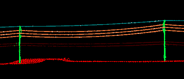
With rapid deployment capabilities and certified pilots who can schedule missions within hours of your request, we ensure minimal disruption to your operations. Whether its routine inspection or an urgent assessment after a storm, our services keep your projects on track and your grid reliable.Unmatched Data Accuracy: Accuracy is the cornerstone of effective transmission line management. Our LiDAR-equipped drones generate high density point cloud data - up to 70 points per square mile - creating precise 3D models of your transmission towers, conductors, insulators, and surrounding vegetation. This level of detail surpasses traditional methods, enabling you to identify issues like sagging lines, vegetation encroachment, or structural misalignments with pinpoint precision.
Unlike ground-based surveys or visual inspections, our LiDAR technology captures comprehensive geospatial data, integrated with GPS and Inertial Measurement Unit(IMU) systems, to produce survey grade 3D maps. These models are seamlessly compatible with PLS-CADD, the industry-standard software used by utilities line design and analysis. Our deliverables empower your engineers to make informed decisions, optimize maintenance strategies, and ensure compliance with regulatory standards.Seamless PLS-CADD Integration: We understand that utilities rely on PLS-CADD for designing, analyzing, and maintaining transmission lines. That's why our Drone LiDAR services are tailored to deliver PLS-CADD deliverables, including detailed point clouds, 3D models, and topographic surveys. These deliverables allow your team to:
Plan maintenance with precise data on tower alignment, conductor sag, and clearance issues.
Manage vegetation by identifying encroachment risks that could lead to outages or wildfires.
Support construction projects with accurate terrain and asset mapping for new transmission lines.
Our processed data is clean, free of noise, and formatted to integrate effortlessly into your PLS-CADD workflows, saving your team time and ensuring consistency across platforms.Enhanced Safety and Cost Efficiency: Traditional inspections often require workers to climb towers or navigate hazardous terrain, exposing them to risks like high winds or unstable structures. Our drones eliminate the need for such dangerous tasks, capturing detailed data from safe distances using high resolution RGB Cameras, thermal sensors, and LiDAR. This not only improves worker safety but, also reduces costs associated with scaffolding, bucket trucks, and helicopter rentals.
For Instance, inspecting a single transmission tower using conventional methods can cost around 5,000 and take several day's. Our drones inspections achieve the same results in a fraction of the time and cost, delivering significant savings while maintaining or exceeding data quality.Comprehensive applications for utilities: Our drone and LiDAR services go beyond routine inspections. They provide versatile solutions tailored to the needs of utilities:
Vegetation management: Identify and map vegetation risks with precision, preventing outages and reducing wildfire hazards.
Structural Analysis: Detect corrosion, cracks, or alignment issues in towers and conductors before they escalate.
Post-Storm Assessment: Quickly assess damage to infrastructure after extreme weather, enabling rapid response and restoration.
Route Planning and Design: Generate accurate 3D models for new transmission lines, streamlining planning and permitting processes.
Why Partner with Us?
Our team of certified pilots and experienced LiDAR solution engineers brings decades of expertise in aerial inspections and geomatics. We use cutting-edge drones equipped with advanced LiDAR and thermal imaging systems to deliver commercial-grade deliverables that meet the rigorous demands of utilities.
Rapid Response: Missions scheduled and executed within hours.
Industry Expertise: Tailored solutions for transmission line inspections, backed by a proven track record with utility companies.
Safety and Compliance: FAA-Certified pilots adhering to strict safety and regulatory standards.
Real World Impact
Consider the success of Duke Energy which leveraged drone technology to inspect transmission towers and solar panels reducing cost and improving reliability. By adopting our drone LiDAR services you can achieve similar results 60% cost savings compared to traditional methods faster, inspections, and richer data for proactive maintenance.
Innovating Drone and LiDAR Services for Transmission Lines
TESCO harnesses cutting-edge technology to revolutionize how transmission lines are surveyed, maintained, and optimized. Our drone and LiDAR services bring precision, safety, and efficiency to your utility projects:
Drone Services:
Aerial Inspections: Using advanced drones, we conduct detailed visual inspections of transmission lines, towers, and surrounding areas, spotting issues that are invisible from the ground.
Thermal Imaging: Detecting overheating components or other thermal anomalies to prevent failures before they occur.
Corridor Mapping: Comprehensive mapping of your transmission corridors to identify obstructions or encroachments that could pose risks.
LiDAR (Light Detection and Ranging) Services:
High-Accuracy Mapping: LiDAR provides unparalleled detail, creating 3D models of your infrastructure for precise planning and analysis.
Vegetation Management: By analyzing LiDAR data, we can predict and manage vegetation growth, ensuring compliance with clearance standards and reducing outage risks.
Structural Analysis: Assessing the health and integrity of transmission structures, identifying wear, damage, or potential failure points.
Integrated Solutions:
Data Integration: Combining drone visuals with LiDAR data for a holistic view of your asset health, offering insights that drive decision-making.
Compliance and Safety: Ensuring all operations adhere to FAA regulations and safety protocols, minimizing risks associated with high-voltage environments.
Custom Reports and Analysis:
Detailed Reporting: Post-inspection, we provide comprehensive reports with actionable insights, prioritized maintenance recommendations, and long-term planning strategies.
Route Optimization: Using our findings, we help design or modify transmission routes for maximum efficiency and minimal environmental impact.
Why TESCO for Drone and LiDAR?
Cutting-Edge Technology:
Stay ahead with the latest in drone and LiDAR technology, tailored to the unique challenges of transmission line management.
Safety First:
Our methods significantly reduce the need for human climbers, enhancing safety for all involved.
Cost Efficiency:
By preempting issues and streamlining inspections, we help lower operational costs and prevent expensive downtime.
Expertise:
With our team's deep understanding of utility engineering, we ensure that every flight and scan translates into actionable, valuable data.
We're not just about adopting new technology; we're about perfecting its application to ensure your transmission lines are not only compliant but also ready for the future. Let us elevate your utility services to new heights with our drone and LiDAR expertise.
GET STARTED TODAY
Our drone services offer a gamechanging approach to managing transmission infrastructure. With faster inspections, superior data accuracy, and PLS-CADD Deliverables we help maintain a reliable gride with reducing cost and enhancing safety.
Ready to evaluate your inspection process? Contact us today and discover how our drone LiDAR services can transform your operations.
PARTNERS
Who We Work With


Additional Partners....
Hoosier Energy
Vectren
MetroNet
BSM Group
Comcast
Crown Castle
DP&L
draftPro
Everstream
Gudenkauf Corporation
Henkle & McCoy Engineering
Hutchins Telecom
IMAN
Jackson County REMC
Johnson County REMC
Kentucky Utilities
Light Stream
Ligonier Telephone Co.
MainStream
LightPath
NIPSCO
SCI REMC
Spectrum
Talman Consultants
Tesinc LLC
Time Warner
Verita Telecom
Verizon Business
WOW
ZAYO

We provide quality services that meet and exceed the industry's standards.

FAQS
What should I do if I have an electrical emergency?
If you have an electrical emergency, such as a utility pole on fire, electrical arcing, or a blown transformer call 911 and your local utility company. Maintain a safe distance from the pole and stay away from any wires that may fall to the ground. Crews will de-energize the line to stop the fire's ability to persist.
What if I see a TESCO Company vehicle in my area or a field survey technician in my back yard?
This means we have been solicited by your local utility company or fiber company to survey the poles in your area. This would be to either add a new wire to the pole or make sure the utility poles in your area are up to compliance with NESC regulations to prevent any future blackouts. The places where poles are placed are called "right-of-ways". "Right-of-ways" are owned by the city and your local utility company. Even when the pole is located on my property? Yes, even when the pole/poles are located on your property. Our field survey technicians access your pole/poles to measure the height of the wires on the pole, read pole tags, and take several pictures to validate our data collection. This data is collected, calculated, remedied according to NESC regulations, and delivered back to the local utility or fiber company.
Do you take on personal utility or fiber projects?
TESCO Company is a business to business company. We work directly with your local utility or fiber companies. If there is a personal concern or project you are interested in completing contact your local utility or fiber company.
Serviced Areas'....
Alabama
Arkansas
Delaware
Florida
Georgia
Illinois
Indiana
Kentucky
Louisiana
Maryland
Missouri
Covering the entire Midwest
Nebraska
New Jersey
North Carolina
Ohio
Oklahoma
Pennsylvania
South Carolina
Tennessee
Virginia
West Virginia
Headquarters